
IMD to set up weather radar in Wayanad after Kerala landslides
IMD to install weather radar in Wayanad nearly a year after Kerala landslides
Almost a year after deadly landslides hit Kerala’s Wayanad district, the India Meteorological Department (IMD) has announced that it will install a new X-band weather radar in the region. The radar will be set up at Pazhassiraja College, Pulpally, with support from the Kerala government.
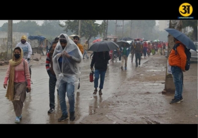
More than 400 people died in the July 30, 2024 landslide tragedy that shocked the entire state. It was one of the worst natural disasters Kerala has ever seen. After the incident, many people blamed the IMD for failing to give proper early warning about the intense rainfall that triggered the landslides.
This new radar is seen as a major step to improve the state's ability to predict and respond to extreme weather events in the future.
What Is an X-band Radar?
The X-band radar is a high-tech weather radar with a range of 100 kilometers. According to the IMD, it is especially useful in hilly and mountainous areas like the Western Ghats, where Wayanad is located. These regions are prone to sudden weather changes and natural disasters like landslides and floods.
The radar will help the IMD monitor rainfall, cloud movement, and storm activity more accurately. With real-time data, the department will be able to issue faster and more accurate weather alerts, helping people and local authorities take timely precautions.
In a post on social media platform X (formerly Twitter), the IMD wrote:
"The X-band radar, with a range of 100 km, is a critical addition to the weather observation infrastructure in the disaster-prone Western Ghats region."
It also said:
"This state-of-the-art system will greatly enhance weather forecasting accuracy, enabling more timely and precise alerts for severe weather events."
Why it matters for Wayanad
The July 2024 landslides in Wayanad were caused by an extremely heavy rainfall event. According to international scientists, over 140 mm of rain fell in a single day, which led to flash floods and landslides in the area. These rains were especially dangerous because the ground was already soaked from two months of monsoon rain.
A team of 24 scientists from India, Sweden, the US, and the UK later concluded that climate change made the rain at least 10% heavier than it would have been otherwise.
But rainfall was not the only cause. Experts said that loss of forest cover, uncontrolled mining, and fragile terrain made the situation worse. A study by ISRO’s National Remote Sensing Centre found that 10 of India’s top 30 landslide-prone districts are in Kerala. Wayanad ranked 13th on the list.
A 2021 research paper by Springer showed that almost all landslide-prone areas in Kerala are in the Western Ghats, which includes districts like Idukki, Ernakulam, Kottayam, Wayanad, Kozhikode, and Malappuram.
A 2022 study further revealed that forest cover in Wayanad dropped by 62% between 1950 and 2018, while plantation farming increased by 1,800%. These changes have made the soil more vulnerable to erosion and have increased the chances of landslides.
Also, around 59% of landslides in Kerala occur in plantation areas, showing how human activity has played a role in making the land unsafe.
ALSO READ: Odisha IAS officer Dhiman Chakma caught accepting ₹10 lakh bribe
How the radar will help
The new radar is expected to improve:
-
Short-term weather predictions (nowcasting)
-
Flood and landslide warnings
-
Disaster response planning
-
Public awareness and safety
Having the radar in Wayanad means that alerts for heavy rainfall or potential landslides can now reach residents faster and with more accuracy. This is especially important in remote areas where people may not have easy access to other forms of early warning.
The Kerala Chief Minister Pinarayi Vijayan was present at the signing of the Memorandum of Understanding (MoU) between the IMD and Pazhassiraja College. He welcomed the decision and said it would play a key role in saving lives in the future.
After the landslides in 2024, the Kerala government was critical of the IMD, claiming it had failed to predict the extreme rainfall. This led to many demands for better equipment and forecasting tools.
The installation of this radar is seen as a response to those demands and a part of India’s larger strategy to improve climate resilience, especially in disaster-prone states like Kerala.
The way forward
Installing a radar is not enough. Experts say that it must be followed by:
-
Training of local disaster management teams
-
Public awareness campaigns
-
Real-time coordination between IMD, state agencies, and local authorities
-
Continued monitoring of environmental changes, such as deforestation and construction on fragile land
With the help of accurate weather data, the government can take timely decisions like evacuation, closing roads, or warning residents about possible danger.
The IMD also plans to install more radars in similar vulnerable regions across India. Wayanad's radar may become a model for disaster risk reduction in other parts of the country.
In summary, the IMD’s decision to install a radar in Wayanad shows how seriously the government is taking the threats posed by extreme weather and climate change. It also highlights the need to protect the environment, especially in areas like the Western Ghats, to reduce the risk of future tragedies.
Related News